Administrative Product Award
Honors products that share data collected through agency programs or the delivery of public services and did not rely on geospatial or mapping data.
BankFind Suite – Summary of Deposits
Federal Deposit Insurance Corporation
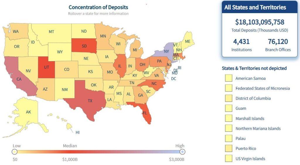
The Federal Deposit Insurance Corporation’s BankFind Suite enables users to learn more about the banks and saving institutions that we expect to safely hold our deposits. A key portion of the suite is the annual Summary of Deposits, which allows financial experts and data analysts to gain key insights into the health and competitiveness of the U.S. banking sector by examining trends in the value of deposits held by banks and saving institutions, their growth and market share distribution. The data is largely reported by insured banking institutions as a part of the FDIC’s required annual Summary of Deposits Survey.
A new user might find the language and methods used in the financial sector difficult to understand, which BankFind Suite attempts to bridge by providing a series of tutorials and explanations. In 2025, a section specifically on the Summary of Deposits was added to the Help page. Included are links to the resources provided to the banks to complete the survey, allowing data users to learn more about that data collection process. The team managing BankFind Suite also tried to make its data both machine-friendly and human-readable in the way they visualize and organize data, as well as the modes available for downloading data such as the robust API.
Geospatial Product Award
Honors products that share administrative data with geospatial aspects through geographic formats or maps.
Landscape Change Monitoring System
Forest Service – U.S. Department of Agriculture
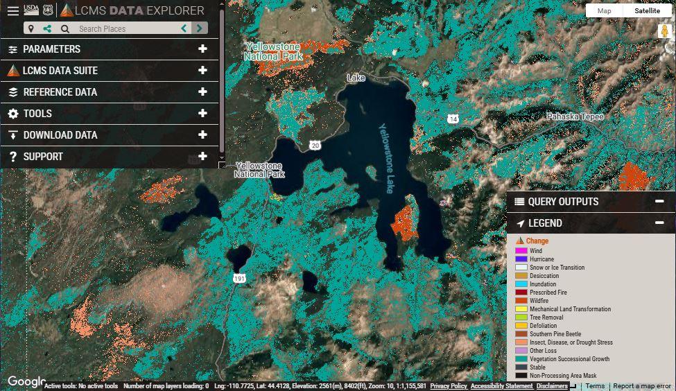 The Landscape Change Monitoring System has used remote sensing data to map landscape changes in vegetation cover and land use across the United States since 1985, allowing users to track wildfires impacts and recovery, monitor local ecologies for climate- and human-caused damage and inform community land use plans. Produced by the USDA Forest Service Field Services and Innovation Center’s Geospatial Office, the change monitoring system is also supported by the U.S. Geological Survey, NASA and the academic community, providing land managers and scientists with the best available mapping resources.
This resource has a strong, clearly documented basis of scientific literature that clearly explains and backs up the methodology used by the creation team. Those papers, along with many other aspects of the system, are easy to find on a well-designed and accessible website. In addition to downloading data for offline use, users have access to several dedicated online tools that explore different aspects of the data. This includes selectively comparing specific years or creating composite timelapses and animated visualizations of map sections to more clearly communicate changes over time to a wider audience.
Statistical Product Award
Honors products that share data collected through the analysis of surveys, scientific studies or other research methods.
Medical Expenditure Panel Survey Household Component
Agency for Healthcare Research and Quality – Department of Health and Human Services
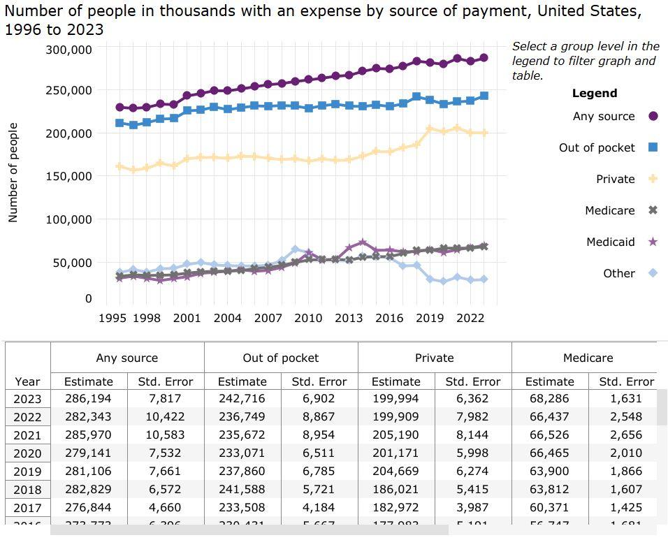 The Agency for Healthcare Research and Quality’s Medical Expenditure Panel Survey Household Component uses information collected from a sample of households to estimate how Americans access and pay for medical care. The federal government, as well as state and local policymakers, use these estimates to better understand trends in health insurance coverage and how different demographic groups, like young people or the elderly, receive health care. The estimates also provide a window into opioid usage and the financial impact of chronic health conditions like asthma or diabetes.
This resource features a dashboard that visualizes useful and commonly in-demand cuts of the data and provides direct downloads and citation data. The website also includes a dedicated section of data files and codebooks accompanied by a detailed explanation of the survey methodology. Finally, the site offers guidance and resources based on users—such as researchers, policymakers or the media—and a platform that makes it easier to access and search through a library of existing publications that draw on the data.
Honorable Mention: Static Product
Recognizes exceptional products that do not have an interactive component such as a dashboard or data explorer.
National Fire Incident Reporting System
U.S. Fire Administration
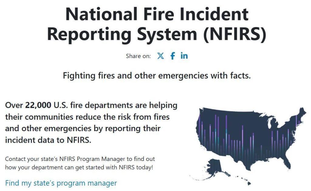 The National Fire Incident Reporting System (NFIRS) was designed to allow fire departments, emergency medical service (EMS) agencies and fire marshals across the country share data on incidents which they have been called to respond. Since the initial iteration of this reporting program was developed in the 1970s by the U.S. Fire Administration, the data on fire and other incidents was used by local and state governments to set priorities and allocate resources, inform the development of fire prevention policies and safety education programs and help industries and federal agencies identify hazards to make our infrastructure, buildings and consumer products safer.
While not featuring an interactive component, the NFIRS data tables were made more accessible through well-organized web pages that explain the coding and reporting systems from both a data-user and data-reporter perspective. They also contain in-depth discussions on the quality of the reported data monitored by the National Fire Data Center.
Aside from recognizing the quality of the product, we are also honoring the long history of this program as it officially sunset on January 31, 2026. It has been replaced by the new National Emergency Response Information System (NERIS) jointly developed by the U.S. Fire Administration, the DHS Sciences and Technology Directorate and the Fire Safety Research Institute.